Performing an identity function (difference + intersection)
In ESRI geoprocessing terminology, there is an overlay function called identity. This is a very useful function to call when you want to keep all the original geometry boundaries of ONLY the input features combined with an intersection of input features.
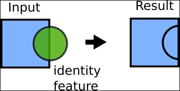
This boils down to a formula that calls for both difference and intersect. We first find the difference (input feature - intersection), then add the intersection to create our results as follows:
(input feature – intersection) + intersection = result
How to do it...
- For all you curious folks who want to learn how to do this, type out the ...
Get Python Geospatial Analysis Cookbook now with the O’Reilly learning platform.
O’Reilly members experience books, live events, courses curated by job role, and more from O’Reilly and nearly 200 top publishers.

