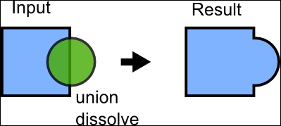
Union polygons with merging (dissolving)
To demonstrate what merging is all about, we will take an example out of the NOAA weather data. It provides an awesome minute-by-minute update of Shapefiles to satisfy your desire to download data. We will look at a week's collection of weather warnings and union these warnings together, giving us the total warning area issued in this week.
A conceptual visualization of our desired results is shown here:
Most of the data is located around Florida, but has some polygons near Hawaii and California. To see the original data or find new data, check out these links:
Get Python Geospatial Analysis Cookbook now with the O’Reilly learning platform.
O’Reilly members experience books, live events, courses curated by job role, and more from O’Reilly and nearly 200 top publishers.

