Chapter 13
Working with Location Information
What's in This Chapter?
- Understanding location-based services
- Choosing a location provider
- Finding a device's location
- Using geocoding to convert an address into a latitude and longitude
- Using reverse geocoding to convert a latitude and longitude into an address
- Configuring proximity alerts
- Using Google Maps
The display of location-specific information such as maps, addresses, and points of interest is a natural feature for mobile devices such as Android. Outside of some niche markets, location-specific information has never had great success on the desktop, primarily because a desktop PC is stuck in a single location. Mobile devices, on the other hand, are carried wherever the user goes. Therefore, as GPS technology has become smaller and cheaper, it has found its way into the cell phone market.
When smartphones appeared, their mapping and location applications were a couple of the key selling features—a perfect example of the possibilities presented by a multitouch user interface. Figure 13.1 shows the basic map application in an HTC EVO 4G.
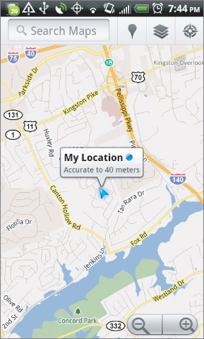
Few other mobile devices had previously made navigating maps as elegant as the pinch-to-zoom, pinch-to-pan operation of maps on the Android screen.
This chapter shows you how to incorporate that same user experience for location and mapping into your own Mono for Android applications. ...
Get Professional Android Programming with Mono for Android and .NET/C# now with the O’Reilly learning platform.
O’Reilly members experience books, live events, courses curated by job role, and more from O’Reilly and nearly 200 top publishers.

