Seeing the GPS File in ArcMap
A GPS file is basically a file of individual three-dimensional spatial points, or fixes. The fundamental form of each point is a latitude value, a longitude value, and an altitude value. When this file was converted to a point shapefile, the latitudes and longitudes were converted to Cartesian northings and eastings. Each altitude became represented as an attribute value associated with the appropriate point.
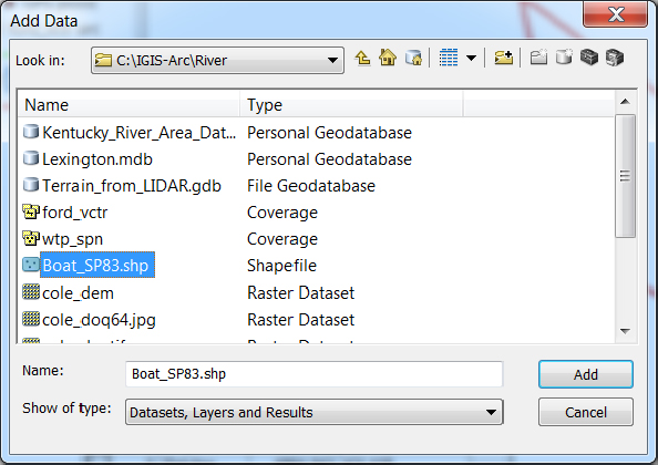
____ 3. Add the layer Boat_SP83.shp:6 To add the file, select File > Add Data > Add Data. In the Add Data window, find the Contents View Type drop-down button. Select Details. Repeatedly press the Up One Level button until it is no longer active. Activate the drop-down menu for the Look in field. Highlight Folder Connections and click. Navigate to the River folder you connected to earlier and pounce.7 Find and highlight Boat_SP83.shp. The results will look something like Figure 2-10. Press the Add button. (Ignore any warnings.) In the left-hand pane (the T/C, as you saw previously), you will see the Boat_SP83 entry. In the right-hand pane, which is formally called a data frame, you should see a GPS track composed of a plotting symbol that looks like a diamond or a dot. The track resembles a fishhook. Compare with Figure 2-11.
____ 4. Make the color of the plotting symbol bright red: The plotting symbol color has ...
Get Introducing Geographic Information Systems with ArcGIS: A Workbook Approach to Learning GIS, 3rd Edition now with the O’Reilly learning platform.
O’Reilly members experience books, live events, courses curated by job role, and more from O’Reilly and nearly 200 top publishers.

