Calculating Flow Direction
The primary data source for hydrologic operations in ArcGIS is a raster of flow direction. This raster is formed by the FlowDirection calculation based on a surface of elevation; for our discussion here, we will call the resulting raster “DirOfFlow.” Each cell in the DirOfFlow raster contains an integer number; these numbers are powers of 2: 1, 2, 4, 8, 16, 32, 64, and 128. (Just why these numbers were chosen, rather than 1, 2, 3, etc., has a historical and computer component, which will be discussed.) Each number indicates a direction, as shown by Figure 8-21.
FIGURE 8-21 Direction code for the flow of water
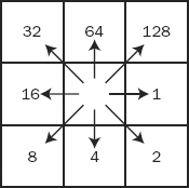
The idea is, simply, that the precipitation that falls, or otherwise appears, on a given cell flows immediately to a single adjacent cell. To which of the eight adjacent cells? The one indicated by the number and the arrow in Figure 8-21, which points in the direction of the steepest descending slope.
For example, consider the simple raster shown in Figure 8-22. The numbers in the cells indicate elevation.
FIGURE 8-22 Elevation values in a tiny raster
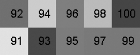
The range in altitude is from 100 to 91, sloping gradually from east to west and a bit from north to south. When the Flow Direction calculation is applied to this raster, the resulting raster looks ...
Get Introducing Geographic Information Systems with ArcGIS: A Workbook Approach to Learning GIS, 3rd Edition now with the O’Reilly learning platform.
O’Reilly members experience books, live events, courses curated by job role, and more from O’Reilly and nearly 200 top publishers.

